GSLEC CAMP MASTER PLAN 1983
(Click on the map for a full-size image. 24-megabyte file, Adobe Acrobat Reader required.)
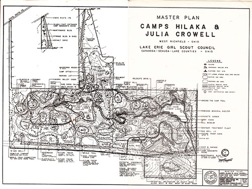
The main excitement in this plan was the large equestrienne center, utilizing the land on the west side of Oviatt Rd (bottom right corner). Note the large parking lot, turnaround, and large barn at reference point #19 .
Inside the loop of road between the stable and Windy Hall is a cleared area for sledding.
Between the Lower Lake and Mabel Smith Shelter, they had planned to re-route the main road. It starts partway up the path to Fernwood and bypasses the steep hill above Garfield.
Over by the gas cut they were going to install a “natural amphitheater”.
On the North side of camp there are sprinklings of new tent units and a new cabin about 300 feet NNW of Gemini. A second new cabin is 200 feet due west of the first.
In the thick part of the driveway panhandle behind the pool is a nature trail with “listening posts”. No idea what that means.
If you take the short side of that little rectangle that sticks out on the bottom right and continue the line straight up through the new barn, across the creek and right through the middle of Beechcliff to the east line, that is the boundary of the original Mason Oviatt Farm.
Shortly after this map was made, Oviatt Road was moved about 600 feet to the west.
Scale of this map says 1” = 200 feet but that can’t be right. Should be 1 cm = 200 feet.
Map is oriented so that East is at the top. (Fun fact: this is how maps were usually oriented before people knew about magnetic north. The word “Orient” means “East” or “to face east”. This is because East faces the rising sun, therefore it is the beginning, the source, the direction from which they would take their bearings).
Here are more detaiils about the 1982 plan. (Note: This is a 51-megabyte file. It may take a few minutes to download to your computer, and you will need Acrobat Reader to open it.)